
Bosque Tour de Norway
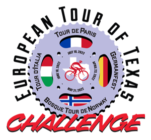
2025 European Tour of Texas
There are 2 different ways to register for our ride. You can register for our ride through our website OR you can register for our ride as part of the European Tour of Texas.
The European Tour of Texas is a series of 4 rides that share a European Theme and small-town Texas hospitality. You can select 3 or 4 rides, combined with a custom jersey.
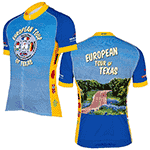
At each of these events, you can recognize other riders in our community by their jerseys – making it easy to start conversations and make new friends.
To get all the information for the ride series and to register, visit the official European Tour of Texas website.
On May 17, 2025, the Clifton Chamber of Commerce will proudly host the 13th Annual Bosque Tour de Norway. After having to cancel the ride for the last two years due to a significant TXDOT project affecting several of our traditional routes and damage from a major flood, we are thrilled to bring the event back. Previously, the ride attracted over 650 participants from across the state, allowing them to experience the stunning landscapes of Bosque County while also soaking in some local Norwegian history. Riders will pass by the Norse Settlement, where Cleng Peerson, known as the “Father of Norwegian Migration,” brought his last group of Norwegian settlers.
This year, we’re excited to unveil several new routes for participants, offering five distance options: 18 miles, 30 miles, 39 miles, 47 miles, and 69 miles. The Bosque Tour de Norway is is the second ride of the European Tour of Texas, a multi-ride series that includes rides in Clifton, Italy, Muenster and Paris. Since Brent Grelle started the European Tour of Texas in 2016, participants have been able to get a custom jersey to commemorate their achievement.
Rest stops will be conveniently located at 10-mile intervals along the routes, providing riders with food, beverages, shade, rest, and bathroom facilities. Local volunteers will be present at each stop to assist and answer questions, ensuring that everyone has a positive experience. In addition, “SAG Wagons” (Support and Gear vehicles) staffed by local cycling enthusiasts will be available throughout the event to support riders.
After the ride, participants are encouraged to explore the beautiful town of Clifton, enjoying local sights, shops, and delicious food and drinks that will surely satisfy post-ride appetites. As hosts of the Bosque Tour de Norway, the Clifton Chamber of Commerce warmly invites everyone to join us for a delightful spring day of cycling and community. Whether you choose to ride or volunteer, it promises to be a day filled with fun and the beauty of our region!


